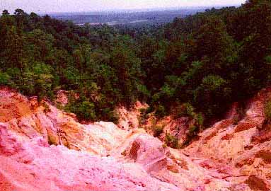
I cannot find Red Bluff in any Mississippi travel guide including the old WPA guide which features many out-of-the-way places. To get there from Hattiesburg go twenty miles west to Columbia, cross to the west side of the Pearl River to Foxworth and go seven miles north to Morgantown. Red Bluff is just north of here. Most people think of South Mississippi as unending square miles of pine forest over a rolling or flat coastal plain. Red Bluff is a surprise. It overlooks the Pearl River and as you can see is several hundred feet in elevation.
Early exploration maps of the Columbia area include Red Bluff, also known as "Mississippi's Little Grand Canyon." Formed by the natural erosion of the west bank of the Pearl River near Morgan Town, Red Bluff is made up of colorful layers of sand, gravel, soil, and clay plunging 200 feet into a creek that empties into the river. The landscape around Red Bluff changes constantly; the road atop the bluff has been pushed back twice to accommodate the ever-widening canyon. Hikers will be disappointed to learn that Red Bluff is located on private porperty, but the unusual formation is easily visible from Mississippi Highway 587 about 15 miles northwest of Columbia. (Marlo Sibley Mississippi: Off The Beaten Path 1997 The Globe Piquot Press Dept FIL P.O. Box 833 Old Saybrook CT 06475 ISBN 1-56440-973-2)
|